THE MAPPING OF THAILAND: AN INTRODUCTION
By
Dawn F. Rooney
This paper was presented at the International Map Collectors’ Society [IMCoS] Symposium, Singapore, November 1991.
INTRODUCTION
Although surveys have been published (Boeles 1966; Maps of Bangkok 1985; Patanonda 1986) and specific maps analyzed (Kennedy 1970; Sternstein 1990), there is no work showing a perspective of the progressive development of Thailand hical in maps. My goal, then, has been to establish a chronology for this geograpknowledge. Maps, charts, town plans, and views are the main sources for research and they provide the illustrations for this evolution. I also used archaeological material to fill gaps. In some cases, these supplementary sources are the only surviving evidence of a particular voyage. To give a feeling of the contemporary environment and people, notes from chronicles and journals of travellers were included in my research.
A hypothetical framework has been derived from these sources. The evidence indicates that the mapping of Thailand began in the south and progressed from the coast to the interior. The coastline was first charted by Asians; European contacts before the sixteenth century were negligible. During a transitional period, Thailand produced maps under foreign direction; this gave way to the final stage of evolution — independent Thai cartography as a full-fledged science. Within this framework, the maps are presented chronologically.
‘South-East Asia’ and ‘Thailand’ are commonly accepted modern political terms. Previously, though, on European maps, the region was the area ‘Beyond the Ganges’ and the country was ‘Siam’. Modern, rather than ancient, place names are used for ease of understanding, as the latter often have several different spellings.
FIRST─FIFTEENTH CENTURIES
The mapping of Thailand began in the south. There, ports along the coast of the gulf have provided shelter and resources for mariners since the first millennium. It is likely the Chinese had charted the east coast and named locations by the third century, even though there are no extant maps. By then, the Chinese were actively trading in the Southern Ocean (Nanhai). A chronicle of the third century lists Hsien-lo (Siam) as one of the new countries (Wang 1958). According to another chronicle of the same period, the navigational and ship-building skills of the Kingdom of Funan were sufficient for Fan-man to sail in a large ship from a port on the east coast of the peninsula across the Chang-hai (Gulf of Thailand) (Lianq-shu in Wheatley 1980, p.15).
In contrast to the high level of Chinese knowledge by the third century, the West knew little about the geography of the gulf. The progressive stages of the West’s perception up to the sixteenth century can be examined through maps from Geographia by Ptolemy, the only relevant early source from the ancient world. The maps were based on the West’s knowledge of the geography of Asia in the second century, even though they date from the printed editions of the first half of the sixteenth century. The representation of Asia on the first map (‘Undecima/Asiae/Tabula’) of 1508 is rather crude (Plate 1). Two places correspond to Thailand —
‘Aurea Chersonesus’ (Golden Peninsula), the peninsular area, and ‘Regio Lestoru (Leistai)’ perhaps southern Thailand. According to Ptolemy, a great gulf bordered on the shores of the peninsula. Looking at the map, it seems likely he was referring to ‘Magnus Sinus’, which Gerini (1909) identified with the Gulf of Thailand though Wheatley (1980) was more correct when he put forth ‘Sinus Perimulicus’, the smaller gulf to the south-west.
The Gulf of Siam was named on a Portuguese manuscript map by Pero C. Reinel dated 1517-8 but it did not appear on a map (‘India/Orien/Talis’) by Laurentius Frisius published five years later in the 1522 edition of
Ptolemy’s atlas (Plate 2). When comparing this map with the previous one, some features remain the same — the hexagonal shape, the numbers along the border attempting to indicate latitudes and longitudes, yet gradual changes are visible; the outline of the coast of Thailand starts to form. The sharp indentations are still present but the coastline has more definition and closely-set parallel lines along the coast mark a clear distinction between land and sea. The projection in the gulf seen on the previous map has receded to form part of the land-mass of Thailand. The Kingdom of Locac (Loac, Lochac) has been identified as the area of the modern town of Nakon Si Thammarat on the west coast of the gulf (Ferrand 1918). The source for the name of this kingdom was Marco Polo who visited it in 1284-5 when Kublai Khan sent him on a voyage from China to Sumatra. Sailing from southern China, he followed the coast of southern Vietnam to the Island of Condor. From there, he crossed the Gulf of Thailand to Locac which he described as an independent state with its own language.
An accurate rendering of the size and shape of Asia were shown for the first time in a World Map of 1375 in The Catalan Atlas. It was drawn by Majorcan pilots and compiled from reports by Franciscan missionaries as well as travellers’ accounts. This map represents a transition from second-hand sources to firsthand information obtained from the discoveries in the sixteenth century.
Less than 60 years after the Catalan Atlas, a Chinese map by Ma Huan was published (in Ying Yai Sheng Lan. ‘The Overall Survey of the Ocean’s Shores’, 1433) based on Zheng He’s naval expeditions to the land of the Southern Ocean between 1405 and 1433. A legend on the map says the fleet engaged in trading with Thailand (Ma Huan 1918). Place names of known trading ports, though, for both the east and west coasts of the gulf, were surprisingly omitted on the map.
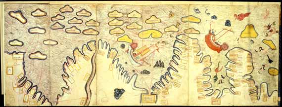
A Thai map of the coast of the gulf in the Traiphum, a religious text, was superior to both the Catalan and Ma
Huan maps but, it cannot be considered a predecessor until a date has been firmly established (Plate 3). The only extant copies of this Thai text date from the late eighteenth century, although it was purportedly written four hundred years earlier. The detail is from one of eight folding panels (Museum fur Indische Kunst in Berlin). The contents and accuracy of this map show a high degree of knowledge by native inhabitants. It is oriented to the south; the capital of Ayutthaya is in the rectangular box at the bottom of the map; the west coast of the gulf begins on the right; the east coast of the gulf unfolds to the left with place names (in Thai) all the way to China including Japan in a cloud in the ocean. Sites along the coast are named with remarkable exactness and detail. The style of drawing, the dark outline, and the vivid colours resemble traditional mural painting and give this map an artistic feeling that belies its geographical importance.
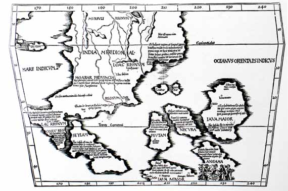
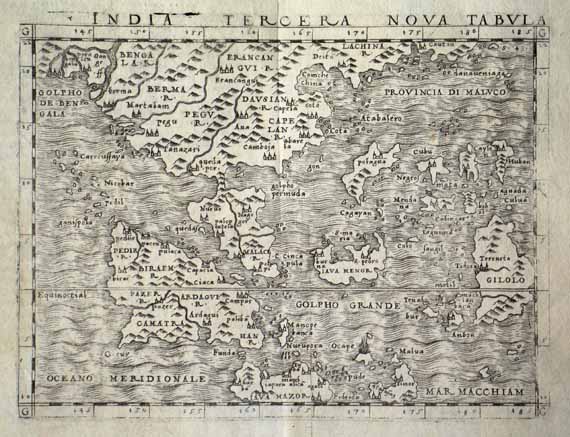
The last example of a Ptolemy-type map (‘India Tercera Nova Tabula’ in Geographia. Venice) is by Jacopo Gastaldi and was published in the first pocket atlas of 1548 (see cover of IMCOS Journal, Autumn 1991) (Plate 4). It was based on travellers’ accounts plus new geographical information. The indentations have
shifted to form the Gulf of Thailand (‘Golpho Permuda’) and the Bay of Bengal; familiar place names, including Singapore (Cincapura), have been added; rivers are still based on theory, and mountains fill the space of unknown geography. This Ptolemaic outline represented the state of the West’s knowledge about Thailand at the end of the sixteenth century. There were many more editions of this atlas but the maps showed little advance in the geography of Thailand.
SIXTEENTH CENTURY
Maps of the sixteenth century showing Europe’s exploration in the East and its interaction with Asia are well-known. Thailand’s role in this regional exploration is less known. Maps of the period focussed on the discoveries of the Spice Islands. To reach these islands from Europe, a ship did not have to sail either along the coast or across the Gulf of Thailand. As a result, Thailand was on the fringe of maps in the first half of the sixteenth century but this changed in the second half when maps started to reflect the advances of the Portuguese in the peninsula.
A map of Asian origin reportedly had some influence on the decision of the Portuguese to go to Thailand. This so-called Java Map, drawn in the first or second decade of the sixteenth century, showed an exceptional knowledge of the geography of South-East Asia. It named, in Javanese, the land of the King of Siam (Crone 1968:91; Nakamura 1964:29). Alfonso de Albuquerque, the second Viceroy for Portugal to India, wrote in a letter to King Manuel I, “this is the best thing I have ever seen” (Birch 1875). The Java Map was lost in 1511 when the Flor de la Mar, a Portuguese carrack, was shipwrecked. Some of the information on the map, though, was salvaged by two pilots (Francisco Rodrigues and Pedro de Alpoym) survivors from the sunken ship. They had made a tracing of the map and transliterated the names. De Albuquerque, intrigued by the map showing lands yet unknown to the West and eager to gain commercial supremacy over the Indian Ocean, sent a mission to Thailand in 1512, marking the first European contact with Thailand.
A map (‘Terza/Tavola’) of 1554 by Gastaldi published in an atlas (Raccolta di Navigationi et Viaggi. Venice)by Giovanni Ramusio shows the route of that mission (Plate 5). Not surprisingly, this map is popularly known as the upside-down map of Asia because of its orientation. From Malacca, the mission sailed through the Straits of Singapore, then north along the east coast of the peninsula to Paam (Pattani), Baplaco (Chumpon), and Odia (Ayutthaya). This map contained the latest geographical knowledge at that time, including the earliest appearance on a printed map of the eastward bend of the peninsula and the name and location of the ‘Kingdom of Siam’.
Although this phrase, ‘Kingdom of Siam’, appeared persistently on European maps, it was incorrect. The kingdom was Ayutthaya. The origin of the word ‘Siam’ seems to be a foreign one. Accounts of visitors in the seventeenth and eighteenth centuries support this origin. For example, Guy Tachard (1688) wrote that the capital was called Siam and that it was a name given by the Portuguese. Since its founding in the middle of the fourteenth century, the kingdom called itself ‘Muang Thai’, the name by which the country is still referred to in modern Indonesian (and its capital Ayutthaya or Sri Yo-thi-ya, a Thai variant of Ayodya). Engelbert Kaempfer (1690) wrote also that the natives use the name “Muan Thai”. Native inhabitants descended from a ‘Tai’ cultural group and have called themselves ‘Thai’ since the beginning of the first modern kingdom at Sukhothai in the middle of the thirteenth century. Simon De La Loubere (1688:7-8) wrote that “The Siamese give to themselves the Name of Tai. or Free...”. Other Asians, such as the Chinese, Persians, Cham,, and Khmer,, used ‘Siam’ as a name for the area known today as Thailand and ‘Siamese’ for the Thai people. Later, Europeans adopted ‘Siam’ as a name for either the country or the capital. La Loubere (1688:8) said that “As for the City of Siam, the Siamese do call it Si-vo-thi-va...[from this name] Foreigners have made Judia. and Odia”.
The strength of Ayutthaya when the Portuguese arrived in the sixteenth century was often underrated in Western accounts and was overshadowed by the Spice Islands. It was the most powerful kingdom in South-East Asia and controlled an area extending south to the Malay Peninsula, west to Lower Burma, and north-east as far as Khorat (which La Loubere calls ‘Corazema’ and says borders on Laos 1968:10). Archaeological finds of glass, beads, and ceramics at ports along the east coast of the peninsula testify that they were active trading centres for at least three hundred years before the Kingdom of Ayutthaya (Promboon 1984).
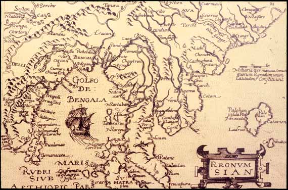
Lake Chiamay (Chiamus, Chia, Chaamay), one of the greatest mysteries in the cartography of South-East Asia, is first evident in maps of the sixteenth century. This large lake, depicted as the source of four, five, or six rivers cascading through the mainland into the Gulf of Thailand, appeared on the Ramusio map in 1554. It was positioned north of Burma and Thailand, between twenty-four and thirty-five degrees latitude north. The lake appeared in various configurations on European maps for over two hundred and fifty years. The unusual thing about this lake is that it was completely mythical.
It is curious that some travellers mentioned people visiting the lake. For example, the Portuguese Fernao Mendes Pinto wrote in the middle of the sixteenth century that the King of Siam went to the Lake of Singipamur, which was called Chiamai by the people and was the source of five rivers (Peregrinacam. in De Campos, JSS 32(1), 1940:15).
The origin of the myth is unknown. L. Sternstein (1976) suggested the name was a mis-pronounciation of Chiang Mai, a northern Thai kingdom. His theory was based on a Thai chronicle which refers to an auspicious lake that influenced the selection of Chiang Mai as a site for the capital. About the city of ‘Chiamai’, Frenchman La Loubere (1688:3) wrote “But the Siamese...do not know that famous Lake, from whence our Geographers made the River Menam arise and to which, according to them, this City [Chiamai] gives its Name: which makes me to think either that it is more distant than our Geographers have conceived, or that there is no such Lake.”
A more widely accepted theory for the origin of this lake is based on an ancient mythological belief known in both Buddhist and Hindu iconography. According to legend, the centre of the universe was a gigantic sacred mountain, known as Mount Meru, in the hinterlands of Tibet. A river flowed from the top of that mountain into a lake and then divided to form four of the great rivers of Asia. The myth of Lake Chiamay was finally dispelled at the beginning of the twentieth century by the identification of the sources of the major rivers of Asia and their interconnections. However, three of Asia’s great rivers — Ganges, Mekong, Yangxi — do originate in the same mountain area of the Himalayas and run in parallel gorges.
The Gastaldi map in the Ramusio atlas of 1554 is a key map in Thailand’s history and identifies the boot-shaped peninsula, place names on the east coast of the first Portuguese mission to Thailand, the names ‘Kingdom of Siam’ and ‘Ayutthaya’, and Lake Chiamay.
Another milestone in Thailand’s cartographical development of the sixteenth century was the publication in 1596-8 of the first separate map of the kingdom. ‘Regnum Siam’ (in Speculum Orbis terrae) by Johannes Metellus, a German scholar, was based on information from maps by Gastaldi (1548) and Ramusio (1554)(Plate 6). The coastal outline of Thailand, the shape of the peninsula, and the placement of the mountains and rivers are similar to the Ramusio map. The shape of Lake Chiamay, however, is different and Ayutthaya was changed from its correct location to the northeastern part of the peninsula. The Gulf of Thailand is not named and its size is markedly reduced on this map. Also, it feature a Portuguese carrack sails towards the Straits of Malacca en route to Thailand.
Ayutthaya’s commanding presence in the sixteenth century was reflected on regional maps by Abraham Ortelius (‘Indiae Orientalis Insularumque Adiacientium Typus’, in Theatrum Orbis Terrarum. 1570); Cornells de Jode (‘Tertiae Partis Asiae’ in Speculum orbis terrarum. 1593); Gerard Mercator (1595), and Baptist Vrient (in Itinerario by Jan Huygen van Linschoten, 1596).
SEVENTEENTH - EIGHTEENTH CENTURIES
Two maps, ‘lndiae Orientalis’ by Jan Jansson (1633); and, ‘India quae Orientalis’ by the Blaeu family (1650), give a regional perspective of Thailand in the middle of the seventeenth century, some fifty years after the
Linschoten map (Plate 7). There are few changes in the outline and coastal names of the last century. Mapping in this century moved in the direction of expanding known information. Area maps included notes on weather conditions, trade, and names of discoverers. Specific maps were drawn of the river access to Ayutthaya and town plans of the capital were introduced.
Ayutthaya was situated eighty kilometres inland from the mouth of the Gulf of Thailand at the juncture of three rivers. Access required manoeuvering along a twisting river upstream against the current. A detail of a chart (‘De Groote Siamse Rievier Me-Nam of Te Moeder Der Wateren’ in Oud en Nieuw Post-Indien. 1725) by Francois Valentyn shows part of this route (Plate 8). It is an unusual map oriented to the East. In the key at the bottom of this map, 101 places along the river and environs are named. Some are transliterations of Thai words; others are Dutch or French names.
A detail of this chart illustrates a longstanding cartographical error on European maps. The Menam River was incorrectly named for several hundred years, extending into this century. ‘Menam’ is the Thai word for ‘river’ (as La Loubere, among others, had noted). Thus, the name “ Menam River’ is redundant. The correct name of the river is, of course, the ‘Menam Chao Phraya’.
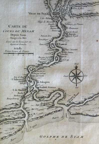
A later chart of the same course (‘Carte Du Cours De Menam...’ in L’Histoire Générale des Voyages. Prevost, Paris, 1750) by Jacques Nicolas Bellin is a typical French map of the period (Plate 9). It contained the most accurate information available at that time and has an elaborate cartouche with the title (the river is mis-named again) and fine detail. Altogether it gives a general feeling of delicate precision. The sand bar at the mouth of the entrance is charted in detail. This difficult passage was noted in all charts and travellers’ accounts of the river.
The original shape of Ayutthaya was a landform fed by three rivers — the Chao Phraya, the Pasak, and the Lopburi, yet it was often depicted as an island on early European maps. The insular shape stands out in two miniature maps: ‘Aracan & Pegu’ by Petrus Bertius dated 1618 (Plate 10); and a regional perspective (‘Asia recens summa cura...’) by Jodocus Hondius in 1632. Shortly after the establishment of the kingdom in 1350, a moat was made by digging a canal and joining it to two rivers. This secured the capital and improved the water transportation. The new configuration was an island shaped like an oxbow. A Town Plan (‘Plan De La Ville De Siam’ in Histoire generale des voyages by Prevost, 1750), based on a Jesuit survey of 1687, shows that form (Plate 11). The shape, layout, and water systems of Ayutthaya have been comprehensively analyzed by Sumet Jumsai (1970).
Ayutthaya was a fortified city surrounded by a brick wall. Inside the wall, the main architectural feature was the Royal Palace compound, in the north of the city. A network of canals intersected by streets divided the town into districts, making a grid. An estimated 140 kilometres of canals linked 500 golden-spired temples. A bird’s-eye view (‘Iudia ou Siam’ in Description de L’Univers. Paris) of 1685 by Alain M. Mallet gives an idea of what the spire-filled city may have looked like to contemporary Europeans (Plate 12). Although the grid conforms to descriptions in accounts, the mountains in the background are purely imaginary.
Another French town plan (‘Plan De La Ville De Louvo’) by Bellin shows the layout of a second capital established in the seventeenth century at Lopburi (Louvo), north of Ayutthaya (Plate 13). Although the map is dated 1750, it appears to be a town plan of Lopburi during the reign of King Narai (1656-1688). The king resided in the palace at Lopburi particularly during the dry season and often received foreign visitors there. Like Ayutthaya, Lopburi was a fortified city with a large fort stratigically positioned outside the wall for protection. The strong foreign presence at Lopburi is shown in this town plan which names the residences of the French and Persian ambassadors, the lodge of the minister of affairs for strangers (‘Barcalon’, a name originally used by the Portuguese, is a mis-interpretation of the Thai title ‘Phra Klang’), and the Jesuit centre for astronomical observations. A note on the plan warns navigators that one of the tributaries is dry for six months of the year.
The extent of the West’s knowledge of the geography of Thailand at the end of seventeenth century is shown on this globe gore (‘Ndie’ in Atlante Veneto, 1697) by Vincenzo Maria Coronelli (Plate 14). The profile of the gulf, the outline of the coasts, the intermittent mountain ranges on the peninsula, and place names show little change from those already established; Bangkok is named and Lopburi, north of Ayutthaya, is identified; the rest of the interior remains unchanged from the previous century except for Coronelli’s elephants and trees; the new addition on this map are the marked sailing routes between Batavia (Jakarta), the headquarters of the Dutch East India Company, and Ayutthaya.
Seventeen years after this map was published, in 1767, the Burmese sacked the capital and ended the four hundred year history of the Kingdom of Ayutthaya. Emphasis on town plans and Charts of the river diminished. Surveys of the next century concentrated on improving sailing instructions and the interior.Guidelines for navigators on the alternating monsoonal winds in the gulf were one of the additions to maps of this period. A remark placed at the entrance to the gulf on a map (‘Carta particolare della Malacca...’ in Dell’ Arcano del Mare. Florence, 1646-8) by Sir Robert Dudley advised that the monsoons changed every six months (Plate 15); and a map (‘Les Isles Philippines’ in Atlas de Toutes les parties connues du globe terrestre. Paris, 1780) by Rigobert Bonne added arrows and names of the months to show the directions of the prevailing winds (Plate 16). A typical cycle for a ship was to enter the gulf in October or November with the easterly winds from the north-east monsoon; to remain at a sheltered port until April or May when the winds reversed direction and brought the south-west monsoon; and, to sail out of the gulf with the westerly winds. Difficulties with the climatic conditions were described by Ralph Fitch, an English trader in Thailand in the seventeenth century. He sailed south from Ayutthaya for two hours and was becalmed; then, he waited one month at that point for favourable winds to sail out of the gulf (Hakluyt 1898:25-29).
Maps of the seventeenth and eighteenth centuries reflected an increasing French influence; and also showed results of surveys from the interior, north of Ayutthaya. ‘Carte Du Royaume De Siam et des Pays’, a French map of 1686 published by Placide, shows the arrival of the first French embassy to Thailand led by the Chevalier de Chaumont on its approach to the Sundra Straits and the route of that mission to Ayutthaya (Plate 17). ‘Le Royaume De Siam avec Le Royaumes Qui Luy sont Tributaires...’ (in Suite de Neptune François. 1700) by Pierre Mortier is a map of Thailand at the beginning of the eighteenth century (Plate 18). It was based on information from the Jesuit mathematicians who set up the astronomical centre at Lopburi and, therefore, reflected the latest geographical information at that time. These Jesuits were commissioned by Louis XIV to verify existing maps and correct soundings on the voyage from France to Siam. The route of these Jesuits between Batavia and Thailand is marked. Inbound, it is almost the same as the route on the Coronelli map but the outbound route is more easterly. Engelbert Kaempfer (1727:4) mentioned the dangers on the route from Batavia to Siam and said there were many small low islands, rocks, and shoals. Two forts at Bangkok are named in the Mortier map, as is Lopburi, but the area north of it remains blank.
Advances in mapping the interior and defining the borders of Thailand by the middle of the eighteenth century are illustrated in a Dutch map (Nieuwe Kaart van India over de Ganges of van Malakka, Siam,... in Atlas van Zeeland. 1760) by Isaak Tirion (Plate 19). There is a clear division between Malacca and Siam on the peninsula; and the borders of Thailand and the surrounding countries of Pegu and Ava (Burma), Kemarat (Shan States), Laos, and Cambodia are suggested.
Two charts by D’Apres de Mannvillette (‘Carte Plate du Golfe de Siam...’ and ‘Plan De L’Archipel De Merguy & Plan De L’Isle Junkseilon’ in Le Neptune Oriental. Paris, 1775) give a comprehensive view of the gulf as it was charted in the late eighteenth century (Plates 20; 21) . The presence of latitude scale, compass roses, rhumb lines, soundings near the coast, anchorages, fairway tracks, and sea-beds represent an unknown sophistication in the cartography of Thailand.
The island of Phuket is recognizable on this chart by shape and position, but probably not by name. It was commonly called ‘Junkceylon’ or a variation (Ianararum, Iunsalao, Jonsalam, Junculan) on European maps. The original name of the island was neither Junkceylon nor Phuket. The native inhabitants have called this island ‘Chalang’, or ‘Thalang’ in Siamese records, since ancient times. The Malay interpretation of this name was ‘Salang’. They added the name ‘Ujong’ (‘headland’) to ‘Salang’. The narrow channel on the north end of the island was not easily seen and the mariners may have thought it was a headland. Later, the Malays dropped the XU’ from ‘Ujong’, leaving ‘Jong’. Names on early European maps, such as Jonsalam and Junculan derived from the words of ‘Jong’ and ‘Salang’. Sometime in the late nineteenth century, the name changed from Junkceylon to Phuket. Why it changed is less clear. Phuket may be a mis-pronounciation of the Malay word ‘bukit’ (‘hill’). Malay influence in coastal names was common as they were the main navigators along the coast and their language was the lingua franca of maritime trading in South-East Asia (Smithies 1988).
Looking at the other place names on this chart, few are recognizable. When pronounced, though, most of them sound the same as the name of the islands today. Only the romanization is different. For example, Lontar (Lanta) and Batao (Topao). Vogels Island, to the east of Junkceylon, is known today as one of the Ko Phi Phi group. ‘Vogels’ derived from the European custom of naming an island after the first person to land on it.
A map (‘Regni D’Aracan Del Pegu Di Siam De Gamboge E Di Laos’ in Atlante Novissimo. Venice, 1785) by Antonio Zatta shows Thailand at the end of the eighteenth century. Mountains and rivers were filled in on the interior; an attempt was made to define the borders; and towns along the main river were named.
The capital was moved south from Ayutthaya to Thonburi, in 1767. Thirteen years later, it was moved across the river to Bangkok where it remains today.
NINETEENTH - TWENTIETH CENTURIES
In 1824, Lieutenant James Low produced a map (‘Siam, Cambodja, & Laos’) of Thailand. It has been studied extensively by Sternstein and his findings have been published in the Journal of the Siam Society (1985;1990). Low claimed it was compiled from Siamese, Burmese, Peguan, and Malayan sources but Macalister (Sternstein 1985:140) pointed out that the outline was taken from a map (‘India extra Gang...’) in a French atlas by Jean Baptiste Bourguignon d’Anville of 1780 and 1782.
In the nineteenth century cartography focussed on two areas: the development of Bangkok as an urban centre; and maps for special purposes — military plans, communications, railways, population distributions, land demarcations, triangulation surveys, and topographie studies.
A reproduction of a Thai military map ‘A Logistics Map from the Reign of Phra Bat Somdet PhraRamahibidoi I’ based on intelligence reports from a campaign in north-east Thailand in 1827 is an example of a special-purpose map (Plate 22) . Like the previous Thai map, it was drawn in mural painting style and from a bird’s eye perspective. But the information is as practical as the drawing is artistic. River systems, mountains, forts, and towns are precisely located and identified.
Another special-purpose map of the same part of the interior and from the same period is by Henri Mouhot, the French naturalist who rediscovered Angkor in Cambodia. He drew ten route maps (now in the Royal Geographical Society in London) for three journeys from Siam to Cambodia and Laos in the years 1858-61. John Arrowsmith, draftsman and map publisher, who had produced earlier maps of South-East Asia, assisted Mouhot in organizing his maps. This sketch map details Mouhot’s route from Korat in north-eastern Thailand overland to Louang-Prabang in Laos. Notations were written on the map by Mouhot.
Its unique position as the only country in South-East Asia that was never colonialized undoubtedly retarded foreign mapping of Thailand. And, perhaps the Thais did not feel the need for maps since precise borders were not established until foreign intervention in surrounding countries forced the delineation of erritorial boundaries in the last half of the nineteenth century. Thus, the arrival of modern cartography in Thailand did not begin until 1875 when the Royal Survey Department was officially established by royal decree (Maps of Bangkok 1984:2). The stamp of the Royal Survey Department appeared on maps thereafter. Five years later, James McCarthy, an Irishman, was hired as Government Surveyor and was subsequently appointed Director-General of the Royal Survey Department, a position he held for sixteen years (Plate 23). Foreign advisors and Thais worked together, under the patronage of King Chulalongkorn, for the next twenty-five years on the mapping of Thailand.
The second area of focus of this period was town plans of Bangkok and charts of the access. Two large scale plans on one sheet (‘Golfe De Siam’) by Captain J.H. Richards in 1866 chart the river from the mouth of the gulf to Bangkok. It gives detailed sailing instructions for navigating across the bar into the entrance of the river.
The earliest known town plan of Bangkok was published in 1828 in a journal of John Crawfurd’s mission to Thailand (Journal of An Embassy to the Courts of Siam and Cochin China) (Plate 24). The title on the map says it was drawn by a native. The place names mix transliterations of Thai and English words. It shows the Chao Phraya River and canals around the city; and the river is still named ‘Menarn’. While unimpressive in content, this small plan has an appealing naivete.
A town plan by the Royal Survey Department was compiled in 1878. Seven symbols represent canals, paddy fields, orchards, tramways, roads, buildings, and houses along both sides of the Menam Chao Phraya. This detail shows the Grand Palace and fortified wall around it. The growth of the city is visible by the concentration of shops and districts grouped around the outer wall of the palace.
The Port of Bangkok was charted by McCarthy and his team in 1878. It was printed in English and showed European private residences, floating houses, and New Road, along the river. Until the last eight years of the nineteenth century, maps were sent to England for making copper plates and for printing. This plan is representative of the last phase of foreign input in the mapping of Thailand.
A detail of a town plan of Bangkok of 1931 is an example of full-fledged Thai cartography (Plate 25). It was printed in four colours which were used to depict symbols. Toponyms on this map are in English. It identifies wooden buildings, railway tracks, dykes, boundaries, and even foot paths. Aerial photography for maps was introduced later in the twentieth century.
The highest degree of sophistication in the mapping of Thailand to date was achieved in 1990 when the Royal Thai Survey Department issued a satellite map of Bangkok (Plate 26). Objects are identified by the visible light picked up from the reflective properties of the earth’s surface such as soil, water, and buildings.
SUMMARY
In summary, the key stages in the evolution of the mapping of Thailand were represented by: the West’s earliest conceptions of the coastline and formation of the peninsula from conjecture; the detailed Thai map of the gulf; the addition of names of ports and coastal routes; the growth of town plans and charts of the river access to the capitals; the delineation of the borders; and the urbanization of Bangkok.
As reflected in the title, this paper is only an introduction. More work needs to be done. Many maps of Thailand undoubtedly lie buried in the archives of Burma and India. The records of all nationalities of missionaries in Thailand need to be conscientiously examined. And, the search for indigenous maps must continue. It is in these directions that I shall turn my future research.
GLOSSARY OF PLACE NAMES FROM TEXT
Old Name Other Spelling Modern Name Baplaco Chumpon Batavia Jakarta Chiamay Chiamus Chia Chaamay Cincapura Singapore Corazema Nakon Ratchasima Junkceylon Ianararum Phuket Iunsalao Jonsalam Ligor Nakon Si Thammarat Loac Locac Nakon Si Thammarat Lochac Louvo Lopburi Odia Iudia Ayutthaya Paam Pattani
REFERENCES:
Abbreviations:
JMBRAS Journal of the Malayan Branch of the Royal Asiatic Society (Singapore) JSS Journal of the Siam Society (Bangkok) Birch, De Gray W., ed. 1875. The Commentaries of the Great Afonso Dalboquercfue. London: The Hakluyt Society, vol 2.
Boeles, J.J. Jan 1966. ‘Some Early Maps of Siam’, Bangkok: TheShell Company Magazine, pp.24-38.
Crawfurd, J. 1828 (rep.1987). Journal of An Embassy to the Courtsof Siam and Cochin China. Singapore: Oxford University Press.
Crone, G.R. 1968. Maps and Their Makers: An Introduction to theHistory of Cartography. London: Hutchinson University Library,
de Campos, Joaquim. 1940. ‘Early Portuguese Accounts of Thailand’. JSS. 32(1), pp.1-27.
Ferrand, G. 1918. ‘Malaka, le Malayu et Malayur’, JournalAsiatique Ile série, tome 11, pp.391-484; tome 12, pp.6-68; 201-41.
Gerini, Colonel G. 1909. Researches on Ptolemy’s Geography ofEastern Asia. London.
Hakluyt, R. 1589. The Principall Navigations. Voiacres. AndDiscoveries of the English Nation. London.
Jumsai, S. 1970. ‘The Reconstruction of the City Plan of Ayudhya’, JSS. In Memorium Phya Amman Rajadhon, pp.301-314.
Kaempfer, E. 1727 (rep. 1987). A Description of the Kingdom of Siam 1690. Bangkok: White Orchid Press.
Kennedy, V. 1970. An Indigenous Early Nineteenth Century Map ofCentral and Northeast Thailand. Journal of the Siam Society, In Memorium of Phya Rajadhon. Bangkok: Siam Society, pp.315-349.
La Loubere, S. de. The Kingdom of Siam. 1688, rep. 1986.Singapore: Oxford University Press.
Ma Huan Ying-Yai Sheng-Lon. 1970. The Overall Survey of theOcean’s Shores. 1433. Fren Ch’eng, ed. London: Cambridge University Press, Hakluyt Society. Extra Series No. XLII.
Maps of Bangkok: A.D. 1888-1931. 1984. Bangkok: SpecialPublication of Royal Thai Survey Department, [in Thai, English summary]
Nakamura, Hiroshi. 1964. East Asia in Old Maps. Tokyo.
Patanonda, Major Ubolwan. 1986. Topographic Atlas of Thailand.Vol. 1: Northern Thailand, [in Thai]
Promboon, S. 1984. The Siamese Maritime Trade, A.D. 1351-1511. in SPAFA Consultative Workshop on Research on Maritime Shipping and Trade Networks in Southeast Asia. Cisarua, Indonesia: Nov. 20-7, 1984.
Smithies, M. Oct 1988. ‘The Languages of InternationalCommunication in Siam’, Pt. 2 ‘Malay’. Living in Thailand. pp.51-54.
Sternstein, L. 1976. ‘In the Hand of Jove’. Hemisphere. 20(2), pp.36-41.
Sternstein, L. Jan-July 1985. ‘“Low” Maps of Siam’. JSS, 73(1&2), pp.132-157.
Sternstein, L. 1990. ‘Low’s Description of the Siamese Empire in 1824’. JSS, 78(1), pp.8-34.
Tachard, G. 1688 (rep. 1981). A relation of the Vovaae to Siam:Performed by six Jesuits sent by the French King, to the Indies and China in the year 1685. Bangkok: White Orchid Press.
Wang, Gungwu. 1958. ‘The Nanhai Trade’, JMBRAS 21(2).
Wheatley, P. 1980. The Golden Kersonese. Kuala Lumpur, Malaya Penerbit University Malaya.
LIST OF ILLUSTRATIONS AND DIMENSIONS FOR MAPS
Notes:
• Dimensions are given in Centimeters
• For the dimensions, width precedes height
• RSTD = Royal Survey Department of Thailand
No. Cartographer Date Title of Map (abbreviated) Dimensions 1. Ptolemy 1508 Undecima/Asiae/Tabula 57.0 x 43.0 2. Frisius 1522 India/Orien/Talis 43.0 x 27.4 3. Anonymous 20th C (?) Traiphum (detail) n/a 4. Gastaldi 1548 India Tercera Nova Tabula 17.0 x 13.5 5. Ramusio 1554 Terza/Tavola 26.0 x 38.0 6. Metellus 1596 Regnum Siam 23.0 x 15.0 7. Blaeu 1650 India quae Orientalis 58.0 x 41.0 8. Valentyn 1725 De Groote Siamese Riever 75.0 x 29.9 9. Bellin 1750 Carte Du Cours De Menam 14.0 x 21.0 10. Bertius 1618 Aracan & Pegu 13.0 x 09.9 11. Bellin 1750 Plan De La Ville De Siam 26.0 x 19.0 12. Mallet 1685 Iudia ou Siam 10.0 x 14.0 13. Bellin 1750 Plan De La Ville De Louvo 17.0 x 21.0 14. Coronelli 1697 Ndie 28.0 x 46.0 15. Dudley 1648 Carta part .(detail) n/a 16. Bonne 1780 Les Isles Philippines (detail) n/a 17. Placide 1686 Carte Du Royaume De Siam 33.5 x 47.0 18. Mortier 1700 Le Royaume De Siam 55.0 x 76.0 19. Tirion 1760 Nieuwe Kaart van India 40.0 x 49.0 20. Mannvillette 1775 Carte Plate du Golfe de Siam 33.5 x 48.0 21. Mannvillette 1775 Plan De LIsle Junkseilon 33.0 x 49.0 22. Anonymous 1827 Logistics Map from (detail) n/a 23. n/a 1875 James McCarthy n/a 24. Crawfurd 1828 Town Plan of Bancok 11.0 x 12.0 25. RSDT 1931 Town Plan of Bangkok (detail) n/a 26. RSDT 1990 Satellite Map of Bangkok (detail) n/a
Top